Simularity Launches Free South China Sea Monitoring Service
October 28, 2020. Tampa, Florida:
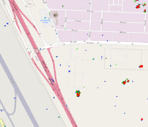
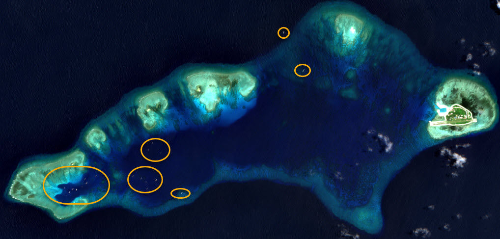
Simularity, a Geospatial AI company, has launched a new free service that monitors activity and provides alerts for the South China Sea. Simularity’s goal is to facilitate the peace process by ensuring all stakeholders in the region, not just the wealthy countries, have current situational awareness. An example of an alert from this service is a newly released report on recent increases in large ships congregating near Pag-asa (Thitu) island, an island that is administered by the Philippines and home to some 200 Philippine civilians, in the hotly contested Spratly Island group.
Large groups of Chinese fishing ships, dubbed “China’s Maritime Militia” have been crowding Pag-asa Island to varying degrees since 2017. On February 20, 2020, Philippine Defense Secretary Delfin Lorenzana confirmed the “intermittent” presence of Chinese vessels surrounding Pag-asa Island in the West Philippine Sea. These ships prevent access by local fishermen to fishing areas near Pag-asa island, and assert dominance over access to the island by sea and air, a precarious position for the inhabitants of the island in that the food supply of the locals and delivery of necessary supplies can be blocked.
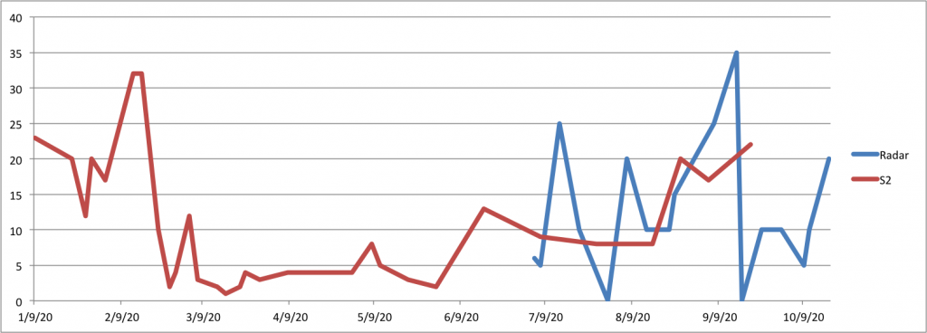
Simularity’s automated analysis of Sentinel 2 satellite imagery through 2020 indicates that there was a heavy presence of large ships (greater than 30 meters in length) near Pag-asa Island in February 2020, but that the numbers tapered off significantly between March and May. The number of large ships in the area started to rise again in June and July, with a sharp increase in August and September, approaching the levels seen in February. Geospatial Intelligence (GEOINT) experts from AllSource Analysis confirmed these results and used Synthetic Aperture Radar (SAR) satellite imagery to count ships in the area for periods when optical satellite imagery was not available due to heavy cloud cover.
The increased availability of satellite imagery and Simularity’s Automated Image Anomaly Detection System (AIADS) make it possible to monitor and alert clients about significant developments in large regions like this one. Simularity’s software can quickly analyze satellite images that cover vast areas of the planet, and keep up with new imagery that arrives daily.
“Taking on a project as big as monitoring the 3.5 million square kilometer South China Sea helps demonstrate the capabilities and speed of our software,” said Liz Derr, Simularity CEO. An exponential increase in new earth observation satellites has led to a flood of new imagery that may hold critical clues about how our planet is changing, and what humans are doing. “Without robust automated analysis tools such as AIADS, much of those insights remain hidden because the mostly manual practice of geospatial analysis is too time consuming to keep up with the ever increasing amount of imagery,” Derr added.
AllSource CEO Chuck Herring stated “Simularity’s AIADS can quickly examine vast areas, pointing out the unusual changes so that expert imagery and geospatial intelligence analysts can focus on the areas of change and provide detailed analysis of the changes. Simularity’s software does the lion’s share of monitoring the vast area of the South China Sea. When unusual changes are found, AllSource’s experts are able to quickly examine and determine the nature of those changes.”
Simularity Inc. is a Tampa, Florida-based Geospatial Artificial Intelligence (AI) company, that specializes in developing robust, accurate, automated AI analysis for satellite imagery to predict, detect and classify significant changes happening on the ground and at sea. For more information about automated large area monitoring, to see additional alerts, and to sign up to get email notifications of each new alert before it is publicly available, visit https://simularity.com/south-china-sea-rapid-alert/
AllSource Analysis leads the commercial imagery intelligence market with a suite of multi- source information and analytic products and subscriptions. In partnership with the world’s leading data resources and an international network of analysts, the AllSource Analyst Network fuses unique content into actionable intelligence for critical decision-makers in energy, financial, government, humanitarian and insurance industries.
Imagery credit: Sentinel 2 “European Space Agency – produced from ESA remote sensing data”
For media enquiries contact:
Peter Koning, Simularity Inc.
peter.koning@simularity.com
Tel: +1-415-873-0943
Additional Press Resources: https://simularity.com/press/
Chuck Herring, AllSource
Tel: +1-303-210-2529