
Products / AIADS
Automated Image Anomaly Detection System
AIADS uses multimodal geospatial data, identifies and classifies unusual changes, and monitors vast areas on a daily basis.
Manual analysis doesn’t scale
Existing solutions rely on manual analysis, which is slow, expensive and does not scale. Customers need automation to analyze images for unusual activity and prioritize the areas of interest.
AIADS automates image analysis and prioritizes images with unusual change.

How it fits your workflow
1
Input
Satellites and drones: optical, multispectral and SAR imagery.
2
AIADS
AI compares each new image with the historical record of the same area and separates normal change from unusual change.
3
Output
Anomaly files and notifications.
AIADS features
Turnkey solution
Ready to run on imagery you already collect.
Fits your workflow
Outputs load into the tools your analysts use.
Fully automated
No manual image-by-image review to find change.
Resolution agnostic
Works from high-resolution commercial imagery to free Sentinel data.
Replace change detection plus manual analysis
AIADS detects anomalies, not just change. It’s faster, smarter and scalable.
Existing options
- Change detection is not completely automated
- Noisy, with too many false positives
- Manual analysis is time consuming
- Results are delayed
- Neither approach scales
Simularity temporal change detection
- Needs minimal analyst input
- Flags only anomalies
- Notifies immediately
- Easily scalable, with low capital cost
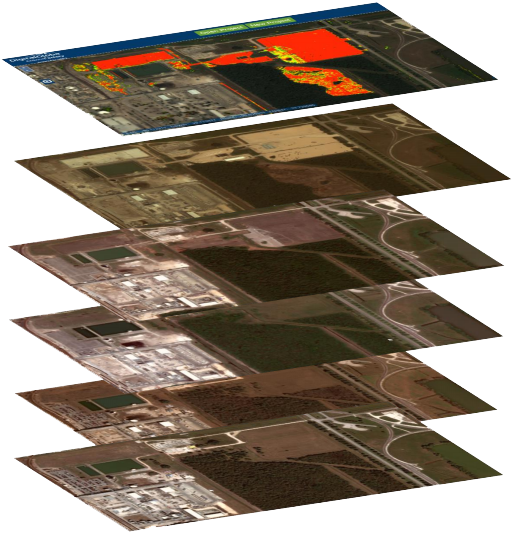
Temporal change detection uses historical context
Detecting construction and land clearing in Houston, Texas. The candidate image from August 22, 2017 was analyzed against earlier images from May 3, April 8 and January 12, 2017 and November 15, 2016. The heat map overlay marks the unusual changes.
See AIADS on your area of interest
Contact us today for more information and a demonstration.