Unlocking the Power of Change Detection — Now on UP42
At Simularity, we believe in transforming satellite and aerial imagery into actionable insight. That’s why we’re excited to announce that our advanced change-detection algorithm is now available as a processing task on the UP42 platform. (See the official UP42 announcement.) UP42 Official Website
In this post we’ll walk you through what the algorithm does, why it matters, and how you — as imagery analysts, infrastructure owners, environmental managers or urban planners — can leverage it to gain a competitive edge.
What the algorithm does
At its core, our algorithm is built on Simularity’s AI-driven temporal change-detection system. It supports two input images (from the same sensor or from different sensors), performs rigorous coregistration (geometric alignment) to reduce misalignment noise, and then identifies and classifies changes between them.
The workflow is:
-
Input two images (ideally with matching processing levels and ground sampling distance within ~25%).
-
Coregister the images via rigid-body transformation to minimise alignment errors.
-
Detect areas of change, outputting three GeoTIFFs:
-
The coregistered source images
-
A change-probability map (in true colour)
-
A change-likelihood heatmap (blue → red scale: red = higher likelihood of change)
-
-
The algorithm is trained to focus on local / non-pervasive changes (e.g., a new building, a cleared patch of forest), while ignoring pervasive or background changes (e.g., shadows shifting, seasonal vegetation variation) to reduce false positives.
Why this is valuable to you
Here are some of the key benefits you’ll get by using our algorithm on the UP42 platform:
-
Scale & Efficiency: Manual change-detection is slow, expensive and hard to scale. With our algorithm you can process vast swathes of imagery automatically, freeing up your team to focus on the most meaningful changes.
-
Automation & Timeliness: Set up automatic workflows so you don’t wait weeks for change-reports. When a significant change is detected, you get alerted — enabling faster decision-making.
-
Prioritisation: Instead of sifting through every image pixel-by-pixel, you can hone in on where change is most likely. That means fewer wasted hours and more targeted action.
-
Accuracy & Quality: Because our coregistration step reduces noise from misalignment, your change-maps are cleaner and more reliable. On top of that, on the UP42 platform you can tweak sensitivity and adjust parameters for your specific use case.
-
Seamless Integration on UP42: By using UP42 you benefit from standardized inputs/outputs (STAC + cloud-native formats), the ability to order and process data in the same environment, stream results into GIS systems (ArcGIS, QGIS) or analytics pipelines — no heavy infrastructure setup required.
-
Broad Use Cases: Our algorithm is truly multi-domain:
-
Vegetation monitoring (forest health, deforestation, wildfire recovery)
-
Infrastructure monitoring (roads, pipelines, railways)
-
Urban & land-use planning (detecting new/illegal construction, tracking land-cover change)
-
Construction site monitoring, fire-risk detection and more.
-
How you can get started
Getting your first change-detection job running is straightforward:
-
Head over to the UP42 marketplace and look for “Simularity Change Detection” under processing algorithms.
-
Select your two compatible scenes (ensure similar geometric/radiometric levels and GSD difference < ~25%).
-
Configure sensitivity or parameter tweaks if desired (e.g., threshold for change likelihood).
-
Run the algorithm. You’ll receive the three output GeoTIFFs described above.
-
Load the change-likelihood heatmap into your GIS/analytics environment and visualise the red-hot zones of change — these are your priority areas for follow-up.
Real-world example
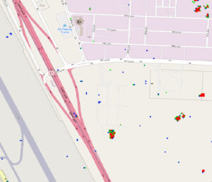
On UP42 you’ll find an example using two images from Airbus. The change-heatmap clearly highlights areas of new construction and cleared vegetation. (See the blog article for imagery.)
Imagine applying this to your asset network: airports, pipelines, forest concessions, mining leases, city districts. The ability to pick up emerging change — proactively and at scale — can make all the difference in risk-management, compliance, operations and planning.
Why we partnered with UP42
At Simularity, we’re always focused on delivering high-impact analytics. Partnering with UP42 means you get the best of both worlds: our specialised algorithm, plus UP42’s robust, scalable cloud-native infrastructure and harmonised data ecosystem.
This means faster time-to-value, fewer headaches in data format orchestration, and more focus on insights rather than plumbing.
Final thoughts
As remote-sensing and earth-observation capabilities continue to proliferate, the real bottleneck is no longer seeing the world — it’s making sense of the changes we see. That’s exactly where Simularity’s algorithm steps in: turning vast volumes of imagery into actionable change-maps you can trust.
If you’re looking to monitor large areas, detect risk sooner, or focus your analytic resources on what truly matters — the change, rather than the noise — then it’s time to give our Change Detection algorithm on UP42 a try.
We look forward to seeing how you harness it for your next mission.
— The Simularity Team