Simularity, a Geospatial AI company, and AllSource Analysis, a provider of geospatial intelligence, have established a new partnership to combine Simularity’s automated vast area monitoring with the deep and scalable expertise from AllSource geospatial intelligence analysts.
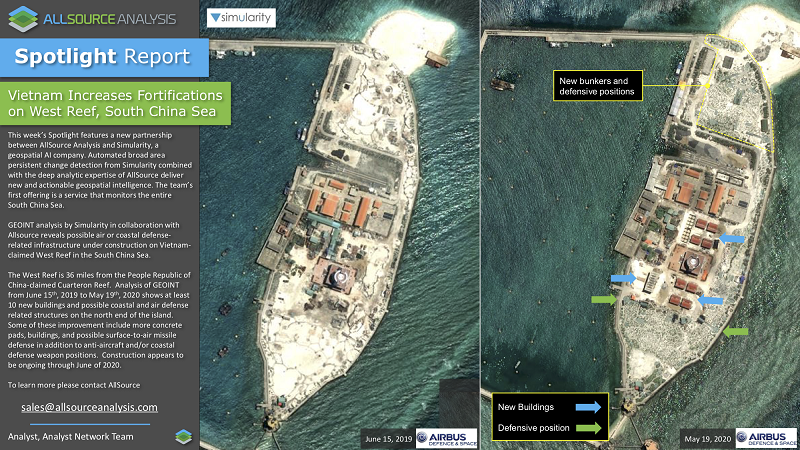
Simularity and AllSource are working together on Simularity’s South China Sea monitoring service. Simularity’s AI scans newly arrived Sentinel 2 imagery for unusual changes. When significant changes are discovered, these changes are then sent to the AllSource Analysis team for them to create finished geospatial intelligence and actionable insights.
Being able to monitor vast areas, such as borders, seas, or countries, is a capability that until now has required imagery and geospatial intelligence analysts that were only affordable for global superpowers. With this partnership, we’re leveling the playing field, so that smaller countries and businesses can have timely, actionable geospatial intelligence.
“Our technology combined with the deep and scalable expertise from AllSource provides our customers with a complete solution: the large area monitoring they want plus the accurate and precise intelligence they need.” said Liz Derr, CEO of Simularity. “Most analysis focuses on known areas of conflict or concern. Our automated wide area scanning helps discover activity that was previously unknown. We’re helping customers avoid unpleasant surprises by providing the insight needed to respond appropriately.”
“Simularity’s AIADS can quickly examine vast areas, pointing out the unusual changes so that expert imagery and geospatial intelligence analysts can focus on these areas of change and provide detailed analysis of the nature and impact of those changes. Simularity’s software does the lion’s share of monitoring vast areas. When unusual changes are found, AllSource’s experts are able to quickly examine them and create accurate and precise intelligence.” stated Chuck Herring, CEO of AllSource Analysis.
Simularity Inc. is a Tampa, Florida-based Geospatial AI company, that specializes in developing robust, accurate, automated AI analysis for satellite imagery to predict, detect and classify significant changes happening on the ground and at sea. For more information on their South China Sea Monitoring Service, see https://simularity.com/south-china-sea-rapid-alert/.
AllSource Analysis leads the commercial imagery intelligence market with a suite of multi- source information and analytic products and subscriptions. In partnership with the world’s leading data resources and an international network of analysts, the AllSource Analyst Network fuses unique content into actionable intelligence for critical decision-makers in energy, financial, government, humanitarian and insurance industries.
###
For media enquiries contact:
Peter Koning, Simularity Inc.
peter.koning@simularity.com
Tel: +1-415-873-0943
Additional Press Resources: https://simularity.com/press/
Chuck Herring, AllSource
Tel: +1-303-210-2529